GALAPAGOS ISLANDS - East Itinerary (Ecuador), NAZCA LINES, MACHU PICCHU (Peru) AND EASTER ISLAND (Chile) 19 Days 18 nights

GALAPAGOS ISLANDS, NAZCA LINES, MACHU PICCHU, EASTER ISLAND

The Galápagos Islands, share the Legend where animals do not fear man, see the Giant Tortoises and blue footed boobies, walk inside lava tubes and swim safely among sharks and sea lions.
Easter Island, is best known for the giant stone monoliths, known as Moai, that dot the coastline. The early settlers called the island "Te Pito O Te Henua" (Navel of The World).
The Nazca Lines are an enigma. Since their discovery, the Nazca Lines have inspired more fantastic explanations.
Machu Picchu is one of the greatest marvels of World. A resting place, the lost city of the Incas.

TRAVEL AGENCY - TOUR OPERATOR - MACHU PICCHU TOURS INFORMATION

GALAPAGOS ISLANDS - East Itinerary (Ecuador), NAZCA LINES, MACHU PICCHU (Peru) AND EASTER ISLAND (Chile) 19 Days 18 nights


Peru Tours DELUXE
PERU LUXURY TOUR


Galapagos Island
MACHU PICCHU-GALAPAGOS ISLANDS-DELUXE TOUR

MACHU PICCHU-GALAPAGOS ISLANDS-TURIST CLASS


Peru Argentina Tours
PERU ARGENTINA TOURS

Titicaca Lake, day night cruise
TITICACA LAKE DAY NIGHT CRUISE

Nazca Lines Overflight
NAZCA LINES OVERFLIGHT

  about usContract BookingSee videoscontact
English versionSpanish version 

1.- Lima and Machu Picchu 5 Days 4 Nights
2.- Cultural Perú 6 Days 5 Nights
3.- Lima Cusco and Machu Picchu 7 Days 6 nights
4.- Archeological Perú 8 Days 7 nights
5.- Perú Short Adventure 9 Days 8 nights
6.- Machu Picchu and The Titicaca Lake 8 Days 7 nights
7.- Discovering Perú 25 Days 24 nights
8.- Short Combination 11 Days 10 nights
9.- Incas Empire 14 Days 13 nights
10.- Perú adventure Extensive 15 Days 14 nights
11.- Lima Canopy Walkway and Machu Picchu 8 Days 7 nights
12.- Lima and the Incas land 9 Days 8 nights
13.- Lima, Cusco, Machu Picchu and Galapagos Islands 15 Days 14 Nights
14.- Lima, Cusco, Machu Picchu and Galapagos Islands 12 Days 11 Nights
15.- Lima, Cusco, Machu Picchu and Galapagos Islands 11 Days 10 Nights
16.- The North and South of Peru 16 Days 15 Nights
17.- Lima, Cusco, Machu Picchu and Easter Island 12 Days 11 Nights


GALAPAGOS ISLANDS - East Itinerary (Ecuador), NAZCA LINES, MACHU PICCHU (Peru) AND EASTER ISLAND (Chile) 19 Days 18 nights


Price per person
Tourist class Hotel 3stars US$ 8846
based on double occupancy

First class Hotel 4stars US$ 9714
based on double occupancy


* The tour budget, can vary according to the availability of flights

Both prices include airfares:
Quito - Galapagos Islands
Galapagos Islands - Quito
Quito - Lima
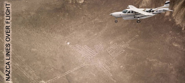
Nazca Lines
overflight
Lima - Cusco
Cusco - Lima
Lima - Santiago de Chile
Santiago de Chile - Easter Island
Easter Island - Santiago

Include:
- 1 night at a Quito hotel and 4 nights on a cruise ship "Galapagos Legend", 3 nights at a Lima hotel, 4 nights at a Cusco hotel, 1 night at a Aguas Calientes hotel, 3 nights at a Easter island
- Vista Dome train: Cusco - Aguas Calientes / Aguas Calientes - Cusco


Itinerary Outline

  • Day 1 - Wednesday: Arrival to Quito
  • Day 2 - Thursday: Quito / Galapagos Cruise
  • Day 3 - Friday: Galapagos Cruise
  • Day 4 - Saturday: Galapagos Cruise
  • Day 5- Sunday: Galapagos Cruise
  • Day 6 - Monday: Galapagos - Quito - Lima
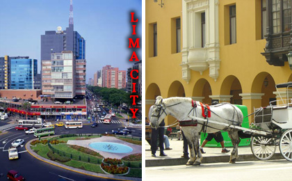
  • Day 7- Tuesday: Lima City Tour
  • Day 8 - Wednesday: Nazca Lines - full day
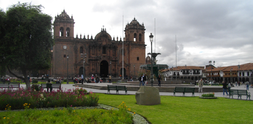
  • Day 9 - Thursday: Cusco, City Tour
  • Day 10 - Friday: Valle Sagrado
  • Day 11- Saturday: Machu Picchu
  • Day 12 - Sunday: Machu Picchu
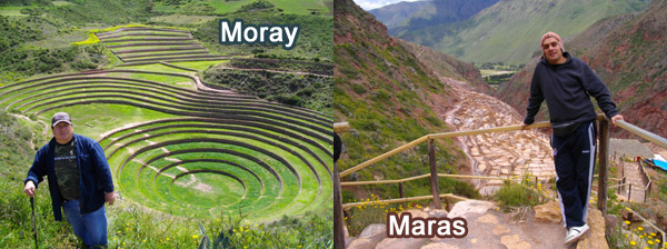
  • Day 13 - Monday: Maras and Moray - Walking in Cusco
  • Day 14 - Tuesday: Cusco to Lima
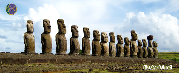
  • Day 15 - Wednesday: Lima to Easter island
  • Day 16 - Thursday: Easter island
  • Day 17 - Friday: Easter island
  • Day 18 - Saturday: Easter island
  • Day 19 - Sunday: Easter island to Lima

* Departures: Wednesday (Galapagos Legend)

ARE YOU INTEREST ON BOOKING THIS TOUR? Ask for availability

Please feel out the below form, we will answer you as soon as possible; the latest in 48 hours.
you can also send us your request for Taylor made programs, if preffer you can also send us an E-mail to:
  info@peruvian-tours.com

Contact Person* 

Phone *    

Your E-mail address please check the spelling carefully otherwise we will unable to contact you:
 

  The package you would like to ask for availability*       

Accommodation required *
 
Arrival Date: Day*
Month*
 
Year* 

  Total Number of Persons Traveling* Number of Adult Persons Number of Children under 12
*Mandatory

Enter below any comments or request you find relevant to your reservation form


ITINERARY

DAY 1 Wednesday - QUITO PICK UP
Upon arrival in Quito, reception and transfer to the select Hotel - overnight ( no meals)

DAY 2 Thursday - Galapagos (Baltra Airport) (More information about The Galapagos Islands)
Departure from Quito or Guayaquil to Baltra (aprox. 2 and half hour flight). Passengers will be picked up at the airport by our guides and taken to the pier to the M/VGalapagos Legend.

Bartolomé
Dry landing. Passengers will see volcanic formations like lava bombs, spatter, and cinder cones. After a hike to the summit you’ll be impressed by the view of the surrounding islands, including the eroded tuff cone of Pinnacle Rock.
During the hike to the summit, travelers will often see colonies of marine iguanas, lava lizards, tiquilla, and various cacti.
Visitors will be able to snorkel and see the Galapagos penguin, sea turtles, and white tipped sharks from a safe distance.

Galapagos Islands - Ecuador

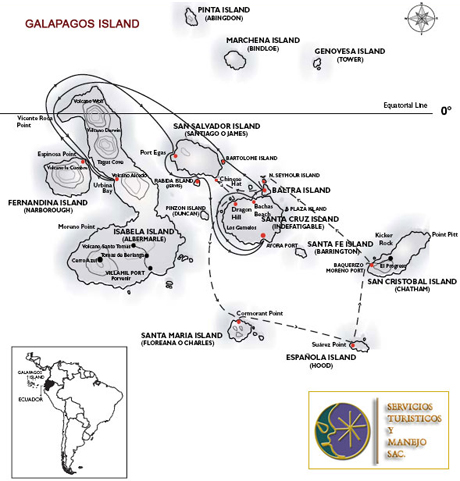
DAY 3 Friday - Urbina Bay (Isabela)
Wet landing. Passengers will visit the fossil beach and coral area. Depending on the season you may be able to observe giant tortoises, land iguanas and flightless cormorants. After the walk we will have time for snorkeling.

Fernandina (Espinosa Point)
Dry landing. Visitors will see the biggest marine iguanas mingling with Sally lightfoot crabs, as well as flightless cormorants nesting sites, Galapagos penguins, Galapagos hawks, and sea lions.
Among the flora and volcanic formations observers will spot brachycereus cactus, and “pa-hoe-hoe” lava and “AA” lava formations. Numerous mangrove beds extend into the sea.

Galapagod Islands - Ecuador

DAY 4 Saturday - Santiago (Egas Port)
Wet landing on a dark sand beach. Most of the landscape is tuff-stone layers and lava flows. You can observe hunting herons, great blue herons, lava herons, yellow crowned night herons and oyster catchers.
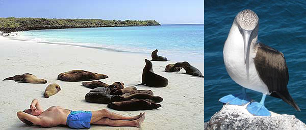
Passengers will see marine iguanas grazing upon algae beds alongside red Sally lightfoot crabs. There is a colony of fur-seals swimming in deep pools of cool water.
Here you can swim and snorkel and find octopuses, sea horses, star fish.

Rábida (Jervis)

Wet landing. The volcano-formed beach is dark red and frequented by sea lions. It’s considered the geographic center of Galapagos because it has the most diverse volcanic rocks on the Islands.
You’ll hike to a salt water lagoon, where flamingos can sometimes be found.
July through September is a good time to observe brown pelicans nesting in the salt bushes. Boobies and 9 species of Darwin’s finches can also be observed.
You can take a dinghy ride by the reefs, as well as snorkel.


Galapagos Islands - Ecuador

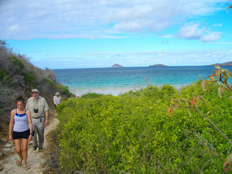
DAY 5 Sunday - Santa Cruz (Charles Darwin Research Station)
Travelers will visit the Charles Darwin Research Station, staffed with international scientists conducting biological research and conservation projects. Here you can admire the giant tortoises that are part of the breeding program.
Visitors can also admire the prickly-pear cactus forest and many land birds. Later on, you’ll have some free time to walk around town and shop for souvenirs.

Santa Cruz (Highlands)
Travelers can trek through the highlands of Santa Cruz and visit Cerro Chato, where you’ll be able to observe the famous giant tortoises.
Additionally, travelers can walk inside the dormant lava tubes.

Day 6 Monday - Santa Cruz (Bachas Beach) / QUITO TO LIMA
Wet landing. This beach is located on north side of Santa Cruz Island.
Here you will encounter many sea birds, marine iguanas, sea turtles, and have the opportunity to swim on the white sand beach.
Return to the Galapagos Legend, check out and transfer to the Baltra’s airport. Return flight to Quito, then you will take your Flight to Lima. Upon arrival reception and transfer to the select hotel (B)

Lima - Peru

Day 7 Tuesday - LIMA CITY TOUR
This tour could start in the morning 9:30 am or 2:30pm. You will be picked up from you hotel. This excursion offers the best combination of the differents attractions in Lima and its three historical periods: pre-hispanic, colonial and contemporary. In Lima, there were several different pre-columbian cultures which are dated thousands of years back. Lima was part of the Inca Empire until was founded by the spaniard Francisco Pizarro on the 18th. of January, 1535. During our guided tour we will travel along its millenary history.

ANCESTRAL LIMA. At the Huaca Pucllana, an archaeological precint build in the IV century A.C., we will have a panoramic view of this magnificent ceremonial and administrative centre which was considered by the Incas a holy village. We will learn about the life and rituals of its ancient inhabitants and admire its typical piramidal building, very characteristic of sacred pre-hispanic edifications which were adored in the coast of Perú.

COLONIAL LIMA. The peruvian Viceroyalty was the most important one in the Spanish Empire and Lima was its capital. The highlights of its historical centre are its architecture and the urban design of the city, found in thold streets filled with colonial houses adorned with moorish-style balconies. Our trip includes the Paseo de la Republica (Promenade of the Republic), Plaza San Martin(San Martin Square) and the Plaza Mayor (Main Square), with their different buildings: Palacio de Gobierno (Government Palace), Palacio Arzobispal the (Archibishop's Palace), the Basilica Catedral (Cathedral Basilica) and the Palacio Municipal (Municipal Palace). We will enter the monumental Convento de San Francisco (Convent of Saint Francis), which displays the biggest collection of religious art in America. We can admire the Choir Room and the Monks’ Library, the Sacristy, with its collection of Zurbaran and Rivera paintings. The Big Patio of the Main Cloister, decorated with sevillan tyles from the XVI century, its beautiful moorish arches and its subterranean crypts known as The Catacombs, where you will feel the presence of Lima's colonial past.

CONTEMPORARY LIMA Visit to the most traditional residential areas in the capital: The Olive Grove of San Isidro, Miraflores and Larco Mar, distinctive tourist centre of contemporary Lima.
After the tour transfer to you hotel. Overnight. breakfast included.

Day 8 Wednesday - LIMA - NAZCA LINES ( FULLDAY) (More information about Nazca Lines)
You will be picked up from your Hotel in Lima at 05:00 am, a private transportation will get you to a ride that will take around 6 hours each way . On the way we will visit the Museum of the site. The Maria Reiche tomb and we will stop at the Over view of Nazca. Cut into the stony desert are large number of lines, not only parallels and geometrical figures, but also designs such as a dog, an enormous monkey, a bird with a wing span of over 100 meters, a spider and a tree. The lines, that represent some sort of vast astronomical pre-Inca calendar, are best seen from the air, we will take a half hour flight above the Lines (Airfare included), after the over flight we will take some time to rest and we will have lunch (included) before to come back to Lima. Upon arrival transfer to your Hotel. (B + L)

Nazca Lines - Peru

Day 9 Thursday - LIMA / CUSCO CITY TOUR
You will be picked up from your hotel and transfer to the airport for your flight to Cusco upon arrival reception and transfer to the select hotel, morning at leisure to acclimatize to the altitude. In the afternoon 2;00pm you will be taken on a city tour and visit a local archeological sites, the Cathedral, Koricancha, Sacsayhuaman and surroundings returning later afternoon 5:30pm to your hotel around and enjoy the hospitality of the local people (B).


Cusco - Peru

Day 10 Friday - SACRED VALLEY
After breakfast at 8:45am you will be taken through the Inca Sacred Valley where life has remained almost unchanged for 500 years. You will visit the impressive village of Pisac and the Indian market, enjoy the beautiful handicrafts on sale and wonder at the many ethnic tribal costumes worn, not just for tourists, but as part of their heritage by the local people. The tour also include the visit to Ollantaytambo fortress and the Chinchero Market Before returning to your hotel in Cusco late afternoon (around 6:30pm)(breakfast and Lunch included)

Day 11 Saturday - MACHU PICCHU 2days 1 night by train (More information about Machu Picchu)
Early morning 5:30am and after breakfast, we'll depart to the train station to our journey to Machu Picchu on Vistadome Train (4 hours) at 9:40am you will arrive to the Aguas Calientes Town from where you will go by bus to the Archeological site (20 minutes); Once there where you will have a guided tour with an English speaking professional guide follow by some time at leisure. You can stay in the area or relax in the hot springs near the Aguas Calientes town (entrance to hot springs not included) Overnight in your Hotel (breakfast included)

Machu Picchu and Huaynapicchu

Day 12 Sunday - MACHU PICCHU - CUSCO
Morning at leisure to explore by your own, you can visit the citadel early when the full magnificence of the site reveals itself in all its majesty, you will have the option to hike up to Huaynapicchu, the pyramid-shaped peak that overlooks Machu Picchu (entrance and bus fee for this day not included on the rate) return to Cusco where you will arrive around 7:30pm. (breakfast included)

MAY 13 Monday - CUSCO – MARAS AND MORAY / WALKING IN CUSCO
Morning - Maras and Moray
Depart this morning to the ruins of Moray. Your guide will take you down into these ruins and explain their function. It is said that the ancient agricultural terraces of circular and concentric shape, which were built by the Incas, were used as a seed-producing area for the principal crops of the empire: maize and potato.
From Moray, you will proceed to Maras, also called Salinas de Maras, these salt-mines have been used since the Tahuantinsuyo. The salt mines have been exploited since Inca times and during the Vice-regency, it was the largest salt producer of the southern highlands.

Maras and Moray

Afternon - CUSCO - MUSEUMS, CHURCHES AND CENTER QOSQO OF NATIVE ART
Enjoy a visit of this magical city as you drive through the main streets with their Inca walls. Visit the San Pedro Local Market where you will see the real life of Cusco and then proceed to “San Blas”, the Artisans’ Neighborhood of narrow and high streets, beautiful little plaza, where the fibers of wool, the pieces of clay and the wood pieces turned into real art pieces. Continue to see the famous Twelve Angles stone, part of the largest Inca wall of Cusco, which used to be the Hatunrumiyoc (Big Stone) palace, built by Inca Sinchi Roca. This is an example of Inca skill with polygonal masonry. Center Qosqo of Native Art (Inca's Dance and Music) (breakfast included)

Day 14 Tuesday - CUSCO TO LIMA
You will be picked up from your hotel and transfer to the airport for your flight to Lima, upon arrival reception and transfer to the select hotel (breakfast included)

Day 15 Wednesday - LIMA - EASTER ISLAND
01:15 am - Lima to Easter Island
05:50 am - Arrive tu Eastern Island
Reception at Mataveri Airport and transfer to Hotel. Free day

Day 16 Thursday - EASTER ISLAND (More information about Easter Island)
We initiate the tour about 3 pm from Hanga Roa's settlement visiting Ahu Vinapu. It was used for the islanders in the year 1.200 A.C. it includes 3 Ahu. The first has 6 moais demolished and painted of red color. The second one has a supposedly feminine moai which had two heads. Finally, the third and the most ancient moai has only removed stones. We will continue our way to the quarry Puna Pau, archaeological site to the east of Hanga Roa. It is a small crater of red dross, from where were obtained the Pukao or hats with which were crowned the moais. Along its antique exit way, there are some incomplete and abandoned moais. We will go on our tour towards Ahu Akivi, the first Ahu restored by the science in the island in the year 1960. The platform with 7 moais is characterized for being one of the few ones located in the center of the island, with its statues facing the rising sun. According the legend, these 7 moais would represent 7 exploratory young men sent before Hotu Matua'a's arrival to investigate the island. Our adventure takes to us to the cavern of Te Pahu, a place used as housing and as temporary refuge in war times. Then, we will return to Hanga Roa, total duration 3,5 hours.

Easter Island - Chile

Day 17 Friday - EASTER ISLAND
Departing from Hanga Roa's town at about 9:30 am, going to the southeast and northeast coast of the Island visiting the Ahu Vaihu temple, which is located 10 km from Hanga Roa. It consists of a stone platform with 8 Moais and 8 pukao dispersed in the proximities. Then, we will go to Ahu Akahanga, the also called as the "platform of the king". The legend tells that Hotu Matua'a's tomb is near this place. There, we will find 4 platforms, 12 Moais, 8 Pukao and towards the interior of this Ahu; it is possible to see the best preserved village of the island.
Later, we will go to Ahu Tongariki, with 15 moais being the biggest Ahu of the island. Then, we will meet Ahu Te Pito Kura, which possesses the highest statue of the island raised in an Ahu, the moai Paro (10 meters of height and 85 tons with a Pukao of 11,5 tons). Close to this ceremonial temple is the great spherical stone that is identified as the center of the universe (Te Pito o Te Henua), as the legend tells, it was brought to the island by Hotu Matua'a in his craft.
Later, we will arrive to Ahu Nau Nau, temple of a complex construction due to its different levels where we will find 5 Moais with Pukao. There, we will see petroglyphs in the backs of the statues. We will continue our excursion to the volcano and quarry Rano Raraku, where there was carved most of the moais of the island using the volcanic rock of its hillsides. There are an estimated number of 400 moais in several stages of carved.
To finish our adventure, we will go to Anakena's wonderful beach. It is a beach of white sands chosen for the arrival of the Ariki Hotu Matua'a and his sister Avareipua. Anakena corresponds to the name of a small cave of an adjacent gully.
Returning to Hanga Roa, we will realize our last stop in the Fundo Vaitea, country estate with an extension of 6.560,80 hectares, which represents 39,6% of the total surface of the island and it was created to achieve an agricultural production capable of sustaining the needs of the whole island, which was achieved years behind. Return to the populated Hanga Roa, total duration 8 hours

Day 18 Saturday - EASTER ISLAND
We will begin our tour at about 8:30 am from Hanga Roa to Tahai's Archaeological Complex, ceremonial center with 3 Ahu, Ahu Vai Uri with 5 moais, Ahu Tahai with 1 moai, and Ahu Lo Te Riku with 1 moai. From this site the visitors can appreciate wonderful landscapes. Then, we will go to Orongo's ceremonial city, ancient ceremonial city located in the west summit of the volcano Rano Kau. It is composed by approximately 53 houses of elliptical shape with flagstone walls and a small square access looking at the sea. In this place were realized the most important ceremony of the second period of the island, the Tangata Manu (“the bird man”). It was carried out until approximately 150 years ago, with the arrival of the first Christian missionaries. Return to Hanga Roa, total duration 3,5 hours.

Easter Island - Chile - Rapa Nui

Day 19 Sunday - EASTER ISLAND TO LIMA - TRANSFER OUT
Breakfast in the hotel.
16.25 pm - Easter Island to Lima
10.15 pm - Arrive to Lima
Transfer to the airport for your flight to Lima and typical farewell. End of our services.

INCLUDE:
Airfares as specify in the program, nights at select hotel based on double occupancy, all transfers, professional biligual guide service, entrance fee, transportation and meals as specify in the program.

NOT INCLUDED
International airfares, airport departure taxes or visa fees, excess baggage charges,  extra expenses for flight cancellations, alcoholic and non-alcoholic beverages or bottled water, snacks, insurance of any kind, laundry, phone calls, reconfirmation of international flights and items ofpersonal nature.


ARE YOU INTEREST ON BOOKING THIS TOUR? Ask for availability

GALAPAGOS ISLANDS (ECUADOR)

The Galapagos Archipelago is located on both sides of the equatorial line approximately 970 km (600 miles) west from continental Ecuador. Local time is -6 GMT. It is formed by thirteen greater islands, six smaller islands, 42 islets and several rocks, which cover a total area of 7,850 km². The largest island is Isabela, with a total area of 4,590 km² which presents the highest point of the archipelago, volcano Wolf, 1,690 meters. 97% of the total area of the isles belongs to the Galapagos National Park, the rest belongs to inhabited and developed areas like the island of Santa Cruz, San Cristobal, Isabela and Floreana, in addition to Baltra an island occupied by the Ecuadorian Armed forces. The Galapagos Archipelago is also a province of Ecuador, whose capital is Puerto Baquerizo Moreno, on the island of San Cristobal. Puerto Ayora, on the island of Santa Cruz, is the city with the highest tourist activity. The islands total population including floating population is around 16,109 inhabitants.

Options for flying into the Galapagos are limited to two islands; San Cristobal and Baltra. Private aircraft must use Baltra as it is the airport equipped with overnight plane accommodations. Seymour Airport on Baltra was recently renovated (2012–2013) to accommodate larger planes.
Until 1969 the only way to visit was on a private or chartered vessel. There was no regular air service until Forrest Nelson's Hotel Galapagos began the first organized tours in April 1969. Soon other travel companies brought in tour ships and yachts,[26] and local fishermen began converting their wooden boats for rudimentary cruising with guests. These vessels were the main source of overnight accommodations in the Galapagos. Today there are about 85 yachts and ships equipped for overnight guests. In 2006 the Baltra military governed island, was opened up to limited overnight camping. Baltra also requires permits by the military government for overnight stays on the beach. Other inhabited islands also allow camping on the beaches designated as "recreational" use to the locals. All of these camping permits are limited to number of people and nights, with most nights not to exceed 3.
Land based hotels are opening on the inhabited islands of San Cristobal, Santa Cruz, Floreana and Isabela. By 2012, more than half the visitors to Galapagos made their tours using day boats and these small hotels. Restaurants, easy access and economy make this an attractive travel option. The cruise tours are still the best way to see all the complex environment and wildlife of the islands.
There are only 116 visitor sites in the Galapagos: 54 land sites and 62 scuba-diving or snorkeling sites. Small groups are allowed to visit in 2–4 hour shifts only, to limit impact on the area. All groups are accompanied by licensed guides.


NAZCA LINES (PERU)

The Nazca Lines are located in the Nazca Desert, a high arid plateau that stretches between the towns of Nazca and Palpa on the pampa (a large flat area of southern Peru). The desolate plain of the Peruvian coast which comprises the Pampas of San Jose (Jumana), Socos, El Ingenio and others in the province of Nasca, is 400 Km. South of Lima, covers an area of approximately 450 km2, of sandy desert as well as the slopes of the contours of the Andes. They cover nearly 400 square miles of desert. Etched in the surface of the desert pampa sand about 300 hundred figures made of straight lines, geometric shapes most clearly visible from the air.

Archaeologists, ethnologists, and anthropologists have studied the ancient Nazca culture to try to determine the purpose of the lines and figures. One hypothesis is that the Nazca people created them to be seen by their gods in the sky. Kosok and Reiche advanced a purpose related to astronomy and cosmology: the lines were intended to act as a kind of observatory, to point to the places on the distant horizon where the sun and other celestial bodies rose or set in the solstices. Many prehistoric indigenous cultures in the Americas and elsewhere constructed earthworks that combined such astronomical sighting with their religious cosmology.
Some Nazca Lines Coordinates
Astronaut
Google Earth coordinates: 14º44'42.79" S - 75º04'47.08"O
Spider
Google Earth coordinates: 14º41'39.63" S - 75º07'21.72"O
Parrot
Google Earth coordinates: 14º41'23.60" S - 75º06'29.41"O
Hummingbird
Google Earth coordinates: 14º41'32.18" S - 75º08'57.05"O
Monkey
Google Earth coordinates: 14º42'26.66" S - 75º08'20.38"O


MACHU PICCHU (PERU)

Machu Picchu "old peak", is a 15th-century Inca site located 2,430 metres (7,970 ft) above sea level is an outstanding example of man's interaction with his natural environment, in the midst of a tropical mountain forest in an extraordinarily beautiful setting, Machu Picchu was probably the most amazing urban creation of the Inca Empire at its height. It is located in the Cusco Region, Urubamba Province, Machupicchu District in Peru. It is situated on a mountain ridge above the Sacred Valley which is 80 kilometres (50 mi) northwest of Cusco and through which the Urubamba River flows. Most archaeologists believe that Machu Picchu was built as an estate for the Inca emperor Pachacutec (1438–1472). Often referred to as the "Lost City of the Incas", it is perhaps the most familiar icon of Inca civilization.

Embedded within a dramatic landscape at the meeting point between the Peruvian Andes and the Amazon Basin, the Historic Sanctuary of Machu Picchu is among the greatest artistic, architectural and land use achievements anywhere and the most significant tangible legacy of the Inca civilization. Recognized for outstanding cultural and natural values, the mixed World Heritage property covers 32,592 hectares of mountain slopes, peaks and valleys surrounding its heart, the spectacular archaeological monument of “La Ciudadela” (the Citadel) at more than 2,400 meters above sea level. Built in the fifteenth century Machu Picchu was abandoned when the Inca Empire was conquered by the Spaniards in the sixteenth century. It was not until 1911 that the archaeological complex was made known to the outside world.

The approximately 200 structures making up this outstanding religious, ceremonial, astronomical and agricultural centre are set on a steep ridge, crisscrossed by stone terraces. Following a rigorous plan the city is divided into a lower and upper part, separating the farming from residential areas, with a large square between the two. To this day, many of Machu Picchu’s mysteries remain unresolved, including the exact role it may have played in the Incas’ sophisticated understanding of astronomy and domestication of wild plant species.

The massive yet refined architecture of Machu Picchu blends exceptionally well with the stunning natural environment, with which it is intricately linked. Numerous subsidiary centres, an extensive road and trail system, irrigation canals and agricultural terraces bear witness to longstanding, often on-going human use. The rugged topography making some areas difficult to access has resulted in a mosaic of used areas and diverse natural habitats. The Eastern slopes of the tropical Andes with its enormous gradient from high altitude “Puna” grasslands and Polylepis thickets to montane cloud forests all the way down towards the tropical lowland forests are known to harbour a rich biodiversity and high endemism of global significance. Despite its small size the property contributes to conserving a very rich habitat and species diversity with remarkable endemic and relict flora and fauna.


EASTER ISLAND (RAPA NUI - CHILE)

Easter Island (Rapa Nui) is a Polynesian island in the southeastern Pacific Ocean, at the southeastern most point of the Polynesian triangle. A special territory of Chile annexed in 1888, Easter Island is widely famous for its 887 extant monumental statues, called moai, created by the early Rapanui people. It is a World Heritage Site (as determined by UNESCO) with much of the island protected within the Rapa Nui National Park. In recent times the island has served as a cautionary tale about the cultural and environmental dangers of overexploitation. Ethnographers and archaeologists now argue that the introduction of diseases carried by European colonizers and the slave raiding that devastated the population in the 1860s had a much greater social than environmental impact.

The name "Easter Island" was given by the island's first recorded European visitor, the Dutch explorer Jacob Roggeveen, who encountered it on Easter Sunday 1722, while searching for Davis or David's island and named it Paasch-Eyland (18th century Dutch for "Easter Island"). The island's official Spanish name, Isla de Pascua, also means "Easter Island".

The current Polynesian name of the island, "Rapa Nui" or "Big Rapa," was coined after the slave raids of the early 1860s, because of Easter Island's geographic resemblance to the island of Rapa in the Bass Islands of the Austral Islands group. However, Thor Heyerdahl has argued that the naming would have been the opposite, Rapa being the original name of Easter Island, and Rapa Iti was named by its refugees.

There are several hypotheses about the "original" Polynesian name for Easter Island, including Te pito o te henua, meaning "The Navel of the land" or "The ends of the land". Pito means both navel and umbilical cord which was considered to be the link between the world of the living (kainga) and the spiritworld Po, lying in the depths of the ocean further East. Since Easter Island is the easternmost Polynesian island it's possible the name refers to it being the "ends" of the world of the living; however after Alphonse Pinart translated it as "the Navel of the World" in his Voyage a l'Ile de Paques published in 1877, this second meaning has been lost. According to some oral traditions, the island was first named Te pito o te kainga a Hau Maka, or the "Little piece of land of Hau Maka". Another name, Mata-ki-Te-rangi, means "Eyes looking to the sky."

Easter Island is one of the world's most isolated inhabited islands. Its closest inhabited neighbor is Pitcairn Island, with fewer than a hundred inhabitants 2,075 km (1,289.35 mi) to the West. It has a latitude close to that of Caldera, Chile, and lies 3,510 km (2,180 mi) west of continental Chile at its nearest point (between Lota and Lebu). (Isla Salas y Gómez, 415 km (258 mi) to the east, is closer but uninhabited).

The island is approx 24.6 km (15.3 mi) long by 12.3 km (7.6 mi) at its widest point — its overall shape has been described as a triangle. It has an area of 163.6 km² (63 sq mi), and a maximum altitude of 507 metres. There are three Rano (freshwater crater lakes), at Rano Kau, Rano Raraku and Rano Aroi, near the summit of Terevaka, but no permanent streams or rivers.


Peruvian Tours y Servicios S.A.C.
www.peruvian-tours.com


GALAPAGOS ISLANDS - NAZCA LINES - MACHU PICCHU - EASTER ISLAND

Inca Trail, Cusco to Machu Picchu
MACHU PICCHU INCA TRAIL TOUR

Lima, Cusco, Machu Picchu, Puno, Titicaca Lake, La Paz, Oruro, Salar de Uyuni
TOURS PERU - BOLIVIA

Peru vacations, Machu Picchu, Cusco, Nazca Lines
NAZCA LINES - CUSCO MACHU PICCHU TOURS

Chan Chan, Lord of Sipan
CHICLAYO AND TRUJILLO TOURS

Lima, City of the Kings
LIMA, CITY OF THE KINGS


AREQUIPA AND
COLCA CANYON

website diseñado por Ideasperu Producciones Multimedia www.ideasperu.net