|
 |
Three main natural regions are distinguishable: the coastal zone (Costa); the hoghlands (Andes or Sierra); and the eastern hills and lowlands (Selva).
The Coastal Zone
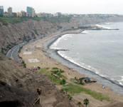
The Costa is an arid, mistly hilly region between the Pacific shore, much of which is bordered by high cliffs, and the Andes farther east. In the north, it is characterized by a low, extremly faulted plateau, a substantial part of which is an almost flat, arable land where water for irrigation is available
|
|
Because of the nature of the terrain and its aridity, settlement is almost enterely confined to river valleys and small sections of the coast, mostly near the mouths of rivers.
A narrow coastal mountain range rises steeply just behind the Pacific shore in the southern part of the Peruavian coastal zone. It is composed mainly of a very rugged surface, much of which is covered by bare hard rocks with deeply incised narrow gorges. Troughlike basins running parallel to this range separate it from the Andes. These flat-bottomed basins are covered with a thick mantle of sediment in which rivers have cut deep valleys. Agricultural settlements that irrigate and cultivate small areas of these valleys are actually oases in this desertlike environment. Unlike other parts of the coastal belt, most of the population in the south resides along its eastern margins, away from the coast and close to the foot of the Andes.
|
|
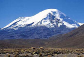
Both the western range and eastern ranges, with peaks rising over 20,000 feet are not continous, which are in most cases arranged in echelon. The high peaks and slopes are permanently snow-covered, with some remnants of glaciers. Volcanoes, active and dormant, are confined mainly to the southern part of the highlands.
The basins and valleys wedged high between the Peruvian Andes are intermont high level surface over which, historically, the majority of Peru's population has been concentrated. Most of them, which lie at altitudes between 10,000 and 15,000 feet, are broad and covered with a mantle of sediment washed down from the neighboring mountains. They are crossed by rivers whose sources are in the Cordillera Occidental or in the basins themselves and which are, in fact, the tributary headwaters of the Amazon river.
The Altiplano of the southern Peruvian Andes (which extends into Bolivia) is made up of some basins and valleys of the high level surface, including Peru's share in Lake Titicaca, with its densely inhabited environs. Only the lower basins and valleys of the high level surface are climatically within the zone suitable for agriculture. The altitude of most of this surface is outside the limit of cultivation or is marginal for some crops, such as potatoes, barley and corn. Much of the high level surface is used mainly as pasture for sheep, goats, alpacas, and llamas.
|
|
|
The Eastern lowlands
The eastern lowlands are generally divided in the selva alta,, the higher hilly areas at the foot of the Andes, and the selva baja, the lower areas farther east (espacially in the northeast) that slope toward the bounderies of Colombia and Brazil. The selva alta is dominated by low, gently sloping eastern spurs of the Andes (1,200-3,000 feet) with broad valleys that have potentially arable land.
|
|
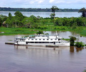
There is a gradual transition to the selva baja, a much lower undulating plain where the relief is dominated by a dense network of rivers and river terraces. It slopes gently northeastward from aproximately 1,200 feet to 300-400 feet. The eastern lowlands are covered with dense tropical rain forest. Over large areas the forest is so dense that access is possible only via the rivers. The eastern lowlands of Peru are, in fact, part of the western margin of the huge Amazon plain.
|

Peruvian Tours y Servicios S.A.C.
www.peruvian-tours.com
PERU GEOGRAPHY |


MACHU PICCHU INCA TRAIL TOUR
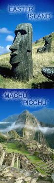
MACHU PICCHU EASTER ISLAND

TOURS PERU - BOLIVIA
|